Virtual layers
Or how to plant trees.
In QGis, a virtual layer is the result of a query that exploits (or not!) the vector layers present in your project, using a SpatiaLite engine (and therefore Spatialite syntax).
It’s all done with the db-manager 
cf. https://docs.qgis.org/3.40/en/docs/user_manual/managing_data_source/create_layers.html#creating-virtual-layers
The performance won’t always be there, but it is possible to build fairly complex spatial queries, and to really help out if you don’t have a good Postgres.
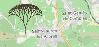
This recursive query builds a fractal tree (remember your early days in logo !), which grows on Saint-Laurent trees (!).
The first branch is hard-coded: a position, a length (400m) which decreases by a factor of 0.8 at each level, an angle of pi/10 to the left and right in relation to the previous branch…
-- simple tree, no parameters
-- racine en EPSG:2154 (834783, 6329867)
WITH RECURSIVE branch(azimuth, x0, y0, x, y, len, n) AS (
	-- first branch
    VALUES (
		pi()/2,                -- azimuth = first orientation
		834783, 6329867,       -- x0, y0 = first point (bottom)
		834783, (6329867+400), -- x, y = second point (top)
		400,                   -- len = branch length
		1                      -- n = level
	)
UNION ALL
	-- other branches
    select azimuth+side*pi()/10,               -- next azimuths (left and right) angle = pi/10
    	x as x0, y as y0,                      -- next seed
    	(x+cos(azimuth+side*pi()/10)*len),     -- next branch extremity
    	(y+sin(azimuth+side*pi()/10)*len),
    	(len*0.8) as len,                      -- next length
    	(n+1) as n                             -- next level
    FROM branch
	-- two sides
    cross join (select -1 as side union select 1 as side) sides
	-- stop
    WHERE n < 8
)
select setsrid(st_collect(makeline(makepoint(x0, y0), makepoint(x, y))), 2154) as tree
from branch
For the syntax of recursion, please read the Postgres doc: https://www.postgresql.org/docs/10/queries-with.html
The principle is to start with a ‘seed’ (the first part of the query below: the ‘VALUES (1)’), then iterate on the recursive term that refers to the result of the query itself.
WITH RECURSIVE t(n) AS (
    VALUES (1)
  UNION ALL
    SELECT n+1 FROM t WHERE n < 100
)
SELECT sum(n) FROM t;
A little addition for a tree: the recursion is split into two branches at each level (the CROSS JOIN (-1, 1)).
A little more realistic
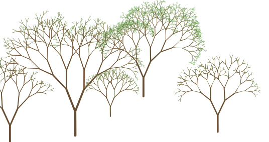
A little more complex to make the construction parameterised:
- the first branch (the trunk) is built from data carried by a layer of points (you can create your own layer or use this one: gpkg).
- the geometry (point) will be the position of the tree
- value ranges and randomness for a more ‘natural’ shape
- use of the ‘m’ value of the nodes for a rendering that varies the thickness of the branches.
A layer (named ‘root’) of the project (qgz) is there only for the initial positions and the parameters,
The virtual layer (the next request) displays the trees (one per record in the ‘root’ table).
The fields used :
- len: length of the first branch (the trunk)
- aperture_min, aperture_max: range of the angle between the branch and the previous branch.
- len_fmin, len_fmax: interval of the length reduction factor
- leef_min, leef_max: number of minimum and maximum levels.
The final SELECT constructs a geometry. To simplify: collect(makeline(makepoint(x0, y0), makepoint(x, y))), i.e. a multi-line of the segments corresponding to each branch.
Replace it with SELECT x0, y0, x, y to get all the nodes.
Plus: the vertices in our geometry contain the ‘M’ values which will be used to render a ‘thickness’ (makepointm rather than makepoint), and the coordinate system is specified.
The request :
WITH RECURSIVE nodes(azimuth, x0, y0, x, y, len, aperture_min, aperture_max, len_fmin, len_fmax, leef_min, leef_max, n) AS (
	--
    select pi()/2, x(geometry), y(geometry), x(geometry), y(geometry)+len, len, aperture_min, aperture_max, len_fmin, len_fmax, leef_min, leef_max, 1
    from root /*the name of the point layer*/

	UNION all

  	select azimuth+side*(aperture_min+rand*(aperture_max-aperture_min)),
	   	x as x0, y as y0,
  		(x+cos(azimuth+side*(aperture_min+rand*(aperture_max-aperture_min)))*len),
  		(y+sin(azimuth+side*(aperture_min+rand*(aperture_max-aperture_min)))*len),
    	(len*(len_fmin+rand*(len_fmax-len_fmin))) as len,
    	aperture_min, aperture_max, len_fmin, len_fmax, leef_min, leef_max,
    	n+1 as n
  	from nodes
  	join (select (abs(random() % 1000)/1000) as rand) r on true
    cross join (select -1 as side union select 1 as side) sides
    WHERE n < (leef_min+(abs(random() % 1000)/1000)*(leef_max-leef_min))
),
branches as (
	select len, x0, y0, x, y, n,
		to_real(((max(n) over ())-n+1))/(max(n) over ()) as w1,
		to_real(((max(n) over ())-n))/(max(n) over ()) as w2
	from nodes
)
-- SELECT x0, y0, x, y
select setsrid(collect(makeline(makepointm(x0, y0, 1.0+(len/10)*w1), makepointm(x, y, 1.0+(len/10)*w2))), 2154) tree
from branches
Style: a polygon-type geometry generator, which constructs a buffer whose distance from the line varies according to the ‘M’ value carried by the nodes in the geometry.
buffer_by_m($geometry)
With the ‘root’ layer switched to ‘edit’ mode, combined with default values applied to the various fields, planting becomes a snap!
The files
under /resources