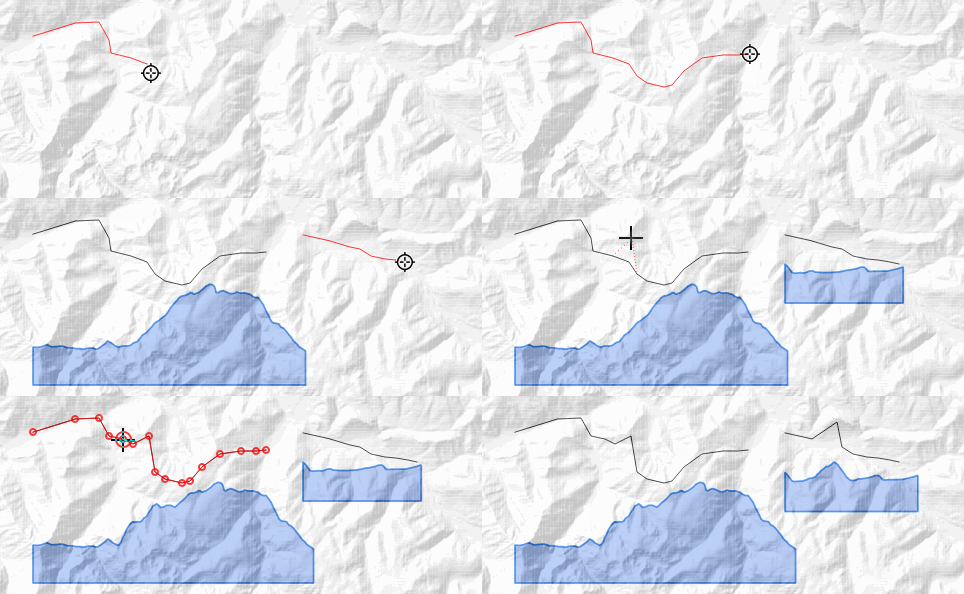
Expressions + style for altitude profile
The idea: propose an expression to dynamically draw an altitudinal profile.

Expressions
One only generates a simple line, the other a polygon, they look similar.
They exploit the interesting with_variable function which allows you to factorize and make the code more readable,
but also :
generate_series: create a series of numbersarray_foreach: transform the values of an arrayraster_value: return the value of a pixel in a raster (for altitude)
The expressions are to be placed in a geometry generator style of line type for the first, polygon for the second.
The name of the raster layer (dem) carrying the altitudes must be adapted (theDemLayer here).
with_variable('transect', smooth($geometry, 3), -- the smoothed geom
with_variable('dem', 'theDemLayer', -- dem layer name
with_variable('fz', 3, -- z exageration
with_variable('x0', x_min(@transect), -- left
with_variable('y0', y_min(@transect), -- bottom
with_variable('xs',  -- x array : distance from path origin, at nodes
	array_foreach(
		generate_series(1, num_points(@transect)),
		distance_to_vertex(@transect, @element-1)
	),
with_variable('zs', -- z array : nodes altitudes (exageration)
	array_foreach(
		generate_series(1, num_points(@transect)),
		@fz * raster_value(@dem, 1, point_n(nodes_to_points(@transect), @element))
	),
with_variable('xz', -- x/z array, zip of preceding x and z arrays
	array_foreach(
		generate_series(1, num_points(@transect)),
		array(array_get(@xs, @element-1), array_get(@zs, @element-1))
	),
with_variable('points', -- points array
	array_foreach(@xz, make_point(@element[0], @element[1])),
	-- > and then, the line geometry
	translate(make_line(@points), @x0, @y0-array_max(@zs)
	)
)))))))))
with_variable('transect',  densify_by_distance( smooth($geometry, 3), $length/50), -- the smoothed geom
with_variable('dem', 'theDemLayer', -- dem layer name
with_variable('base_height', 1000, -- base height
with_variable('fz', 3, -- z exageration
with_variable('x0', x_min(@transect), -- left
with_variable('y0', y_min(@transect), -- bottom
with_variable('xs',  -- x array : distance from path origin, at nodes
	array_foreach(
		generate_series(1, num_points(@transect)),
		distance_to_vertex(@transect, @element-1)
	),
with_variable('zs', -- z array : nodes altitudes (exageration)
	array_foreach(
		generate_series(1, num_points(@transect)),
		@fz * coalesce(raster_value(@dem, 1, point_n(nodes_to_points(@transect), @element)), 0)
	),
with_variable('xz', -- x/z array, zip of preceding x and z arrays
	array_foreach(
		generate_series(1, num_points(@transect)),
		array(array_get(@xs, @element-1), array_get(@zs, @element-1))
	),
with_variable('points', -- points array
	array_foreach(@xz, make_point(@element[0], @element[1])),
	-- > and then, the polgygon with two additionnals bottom points
	translate(
		make_polygon(make_line(
			array_append(
				array_append(@points,
					make_point(array_max(@xs), 0) --array_min(@zs)-@base_height)
				),
				make_point(array_min(@xs), 0) --array_min(@zs)-@base_height)
			)
		)),
		@x0, @y0-array_max(@zs)
	)
))))))))))
The files
- repo : https://github.com/xcaeag/Qgis-tips
- style for simple ligne : resources/style-line.qml
- style for polygon : resources/style-poly.qml